


In 2022, the National Historical Publications and Records Commission (NHPRC) at the National Archives awarded AHC an Archival Projects Grant to rehouse, arrange, and create publicly accessible finding aids for collections that document populations and land use in and around Atlanta. We are thrilled to announce that all collections have been processed and are now available to view at the Kenan Research Center.
With this funding, AHC processed four collections: the Atlanta Real Estate Board appraisals, Atlanta Urban Design Commission records, Atlanta Urban Design Commission visual arts materials, and the Atlanta Department of City Planning records. Together, these collections provide a multi-faceted insight into historic gentrification and land use in Atlanta, which in many ways exemplifies national trends.
Collection Overviews
Atlanta Department of City Planning records
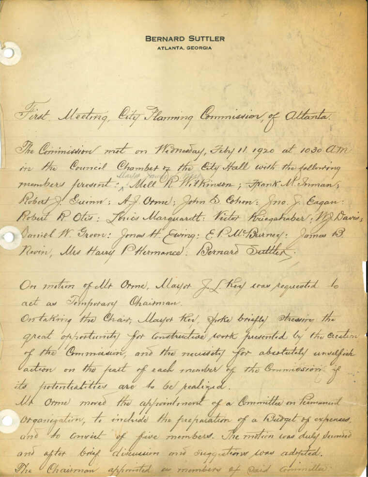
Box 1, Folder 1, MSS 1268
The collection contains meeting minutes from Atlanta’s Department of City Planning, which oversees Atlanta’s housing, buildings, design, and zoning. These minutes document public opinion about city development, growth, and gentrification as well as research into city decisions, financial and project planning, ordinance proposals, and finalized legislation. Researchers can use the collection to learn about city policy regarding land use in different neighborhoods, what Atlantans thought about these decisions, and how some, usually Black Atlantans, suffered under government policy while others, usually white Atlantans, benefited.
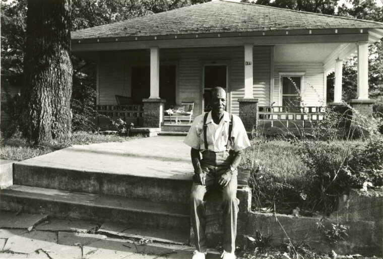
Atlanta Urban Design Commission Records and Visual Arts Materials
Box 13, Folder 5, MSS 1272
The city of Atlanta Department of Budget and Planning established the Atlanta Urban Design Commission (AUDC) in 1975 as part of the Historic Preservation Program “to maintain and enhance the city of Atlanta through the preservation of its historical and architectural heritage and to prevent the destruction of cultural assets.” It is responsible for developing and administering the city’s historic preservation and urban design activities, including designating zoning protection for buildings, sites, and districts based on their historic, architectural, and/or cultural significance.
Most of the manuscript collections pertain to historic nominations, the bulk of which are architectural surveys that describe building structures and landscapes by neighborhood. These surveys contain a building’s address, owner, neighborhood, condition, history, construction date, and local significance. There are also historic nomination forms that document the nominee’s history, correspondence, meeting minutes from the commission, and nomination and acceptance packets.
VIS 443.112.002
The visual arts collection is divided into three series: Series I: Neighborhoods; Series II: Georgia architectural and historic property surveys; and Series III: Maps. AUDC generated these materials, gathered by trained volunteers and unidentified photographers, to document and study the neighborhoods and important structures to gauge their historic significance. Materials depict residences, commercial buildings, streetscapes, religious structures, schools, cemeteries, industrial sites, parks, and government buildings. Also included are floor plans, concept drawings, and architectural drawings.
In addition, nearly 4,000 images have been digitized from the AUDC visual arts materials and are available to view on Album.
Atlanta Real Estate Board Appraisals
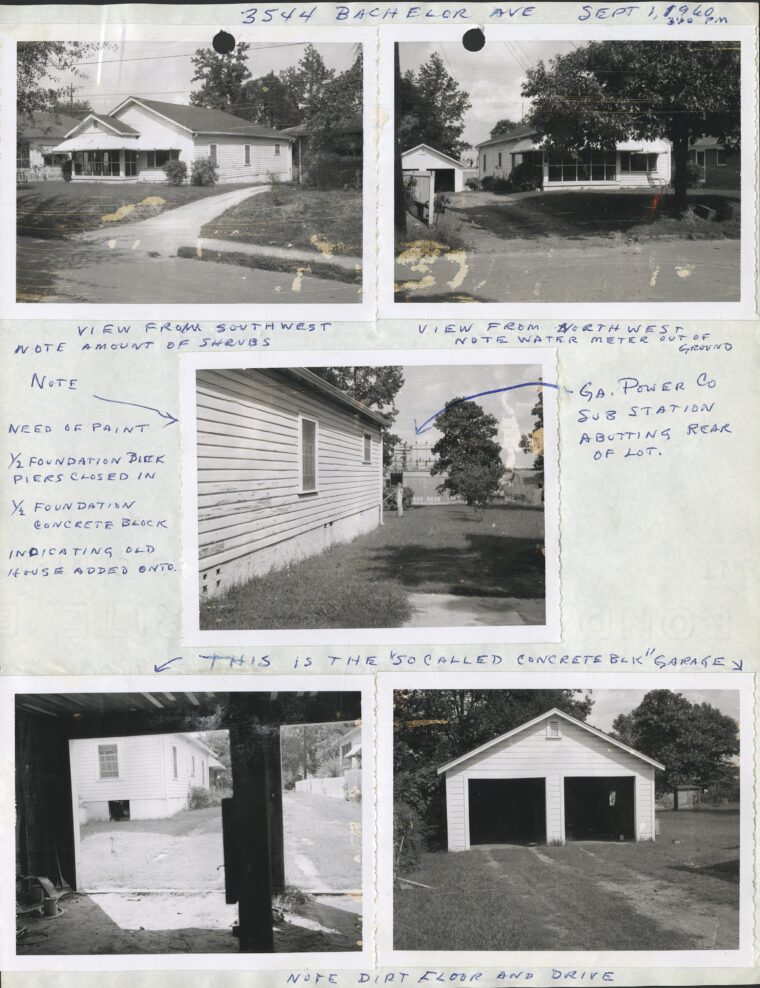
Box 160, Folder 20, MSS 1281
The Atlanta Real Estate Board created over 10,000 real estate appraisals between 1924 and 1983, thousands of which document homes and buildings in historically Black neighborhoods that are typically not included in other resources such as the Sanborn Fire Insurance Maps.
Appraisals document the monetary worth of property throughout metro Atlanta which includes land lots, residences, and businesses; financial assessments usually include reasoning and research, as well as blueprints, photographs, description of the property, and comparable market data. Because they document numerous Atlanta neighborhoods over sixty decades, they offer insight into the worth of land in different areas during years of rapid expansion. Therefore, not only could researchers learn about specific homes and neighborhoods, but they could also compare land worth in predominantly Black neighborhoods with that in predominantly white neighborhoods.
How can these collections be used in research?
The Atlanta History Center has numerous resources (see our Homes & Neighborhoods page for how to get started with property research) which can aid in land use and property research, including Sanborn Fire Insurance Maps, plat maps, city directories, building permits, and more. The collections processed through the NHPRC grant not only fill gaps in our holdings but also strengthen the AHC’s documentation of land use and historic properties.
Through the Atlanta Urban Design Commission (AUDC) records and visual arts materials, we can now offer expanded documentation and imagery highlighting many of Atlanta’s neighborhoods and specific properties.
The Department of City Planning records provide public discussion of building structures, such as those large civic venues developed for the betterment of the city and its citizens. Such structures include the Municipal Market in the 1920s, later known as the Sweet Auburn Curb Market, or the Atlanta-Fulton County Stadium in the 1960s, which has since been demolished. These records now offer additional resources highlighting city planning and provide public opinion and insights.
Additionally, the AUDC materials and the Atlanta Real Estate Board Appraisals have not only expanded which neighborhoods we have information on, but they have also expanded the decades we have information on that we have and are able to make accessible to the public. The AUDC records offer property surveys and photographs, while the appraisals — dating back to the 1920s — include financial details, architectural drawings, and floor plans. Because some properties appear repeatedly in these appraisals, researchers can even trace changes to specific properties over time.
Thanks to the NHPRC-funded processing and improved access, new avenues of research are now possible. Together, these collections provide a more comprehensive view of land use in Atlanta — from local government and public perspectives in the Department of City Planning records, to visual documentation in the AUDC materials, to a private company’s opinion on land and property valuation in the Atlanta Real Estate Board Appraisals.
As a part of the grant, AHC also produced a webinar series and blog posts detailing each collection, which can be viewed on our NHPRC Landing Page.
If you would like to make an appointment to view these records, the Kenan Research Center is open by appointment Wednesday – Saturday, 10 am – 4 pm. Please contact reference@atlantahistorycenter.com to make an appointment.